Weather has been nice for a while. The calendar says it is still winter, but the temperatures feel like spring. I have a National Park pass and the last time I used it was in October of last year when a group of us hiked past May Lake to the base of Mount Hoffman. Taylor and Lisa where scheduled to be out of town and I just got my new digital camera a few days ago. The itch to get outside was growing again and events seemed to converge. It was go time. Stuart and I packed up some things and took off Saturday morning. The plan was to spend the day and night in Yosemite and come home the next day.
When we reached the highway 120 entrance we encountered
a line of cars that moved ever so slowly. A few minutes though and
we were through. I made a quick stop at the first valley viewpoint
and turnout.
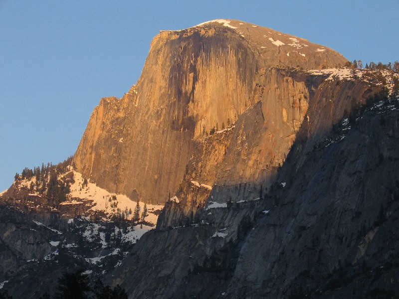
 I snapped a couple of quick shots with the camera. Half Dome always
looms large when you first see it. For me it just seems much larger
than life for a split second, like some surreal zooming film effect.
No camera or zoom lens can ever capture that emotional response.
I snapped a couple of quick shots with the camera. Half Dome always
looms large when you first see it. For me it just seems much larger
than life for a split second, like some surreal zooming film effect.
No camera or zoom lens can ever capture that emotional response.
 Next stop is Bridalveil Falls. We get right up to the base at the
end of a very short walk from the parking lot. The flow is moderate
and the mist is moderate. We have no rain gear and did not need it.
In a few days that may change as the flow quickens with the warmer temperatures.
I am afraid to pull out my camera in the mist, but I do get a couple of
shots off, including this one.
Next stop is Bridalveil Falls. We get right up to the base at the
end of a very short walk from the parking lot. The flow is moderate
and the mist is moderate. We have no rain gear and did not need it.
In a few days that may change as the flow quickens with the warmer temperatures.
I am afraid to pull out my camera in the mist, but I do get a couple of
shots off, including this one.
 A short drive eastward and I stop to snap a photograph of Sentinel Rock.
The Sentinel Beach area is closed and I am disappointed. I briefly
consider walking out to the beach but figure that many photo opportunities
will arise. I can fit 98 full size, superfine quality images on my
256 MB compact flash card. I need to keep that in mind this weekend.
I stop at the Swinging Bridge turnout and we walk out to the Swinging Bridge
picnic area.
A short drive eastward and I stop to snap a photograph of Sentinel Rock.
The Sentinel Beach area is closed and I am disappointed. I briefly
consider walking out to the beach but figure that many photo opportunities
will arise. I can fit 98 full size, superfine quality images on my
256 MB compact flash card. I need to keep that in mind this weekend.
I stop at the Swinging Bridge turnout and we walk out to the Swinging Bridge
picnic area.
 We look around, play some in a snowfield and I snap some shots of Yosemite
Falls which can be seen from the Swinging Bridge.
We look around, play some in a snowfield and I snap some shots of Yosemite
Falls which can be seen from the Swinging Bridge.
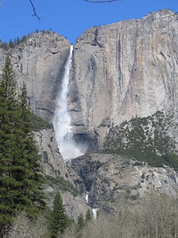 I also try out the 3X optical zoom. This shot shows the lower falls
and the ice pile at the bottom of the upper falls.
I also try out the 3X optical zoom. This shot shows the lower falls
and the ice pile at the bottom of the upper falls.
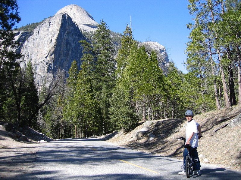 After checking in we stow our gear and pull out the bikes. We end
up touring Happy Isles and on the way to Mirror Lake I snap a shot of Stuart
in front of North Dome. We walk our bikes up part way up to Mirror
Lake. Once there we take a walk around, play in the sand and snap
a few more photos.
After checking in we stow our gear and pull out the bikes. We end
up touring Happy Isles and on the way to Mirror Lake I snap a shot of Stuart
in front of North Dome. We walk our bikes up part way up to Mirror
Lake. Once there we take a walk around, play in the sand and snap
a few more photos.
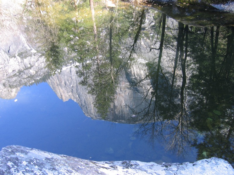 One is of Half Domes face reflected in the water of Mirror Lake.
The only flat, calm part I could find.
One is of Half Domes face reflected in the water of Mirror Lake.
The only flat, calm part I could find.
Once we done playing in the sand and a small patch of snow we ride
on.
 We go past some unnamed falls on the North wall west of North Dome and
look back at Half Dome. We started to ride out to El Capitan for
a sunset but find out that the bike path doesnt seem go directly out the
two miles, later it turns out we just missed the hiking trail out there.
So we turn around back toward Curry Village past the Yosemite Lodge, LeConte
Memorial and skating rink. Bikes are great for getting around!
We go past some unnamed falls on the North wall west of North Dome and
look back at Half Dome. We started to ride out to El Capitan for
a sunset but find out that the bike path doesnt seem go directly out the
two miles, later it turns out we just missed the hiking trail out there.
So we turn around back toward Curry Village past the Yosemite Lodge, LeConte
Memorial and skating rink. Bikes are great for getting around!
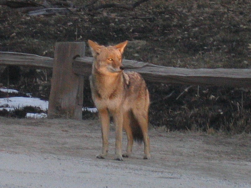 Just before we get to Curry Village we see a coyote standing in the middle
of the road. We get pretty close and just watch as cars stop or make
illegal u-turns to get a view.
Just before we get to Curry Village we see a coyote standing in the middle
of the road. We get pretty close and just watch as cars stop or make
illegal u-turns to get a view.
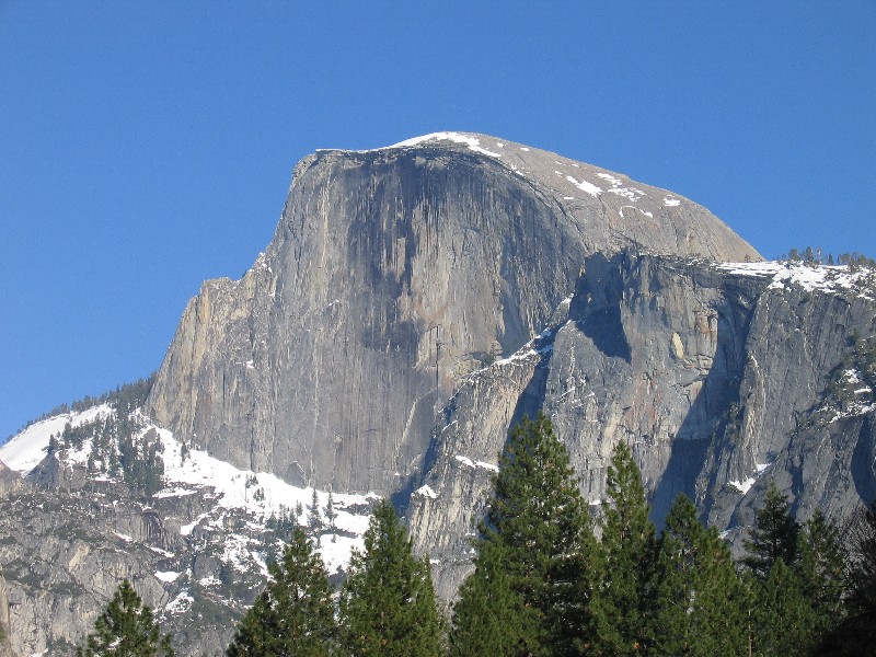
 We
snap quite a few shots of the coyote and of the setting sunlight on the
Half Dome. After some cafeteria salad and pizza its bedtime.
We
snap quite a few shots of the coyote and of the setting sunlight on the
Half Dome. After some cafeteria salad and pizza its bedtime.
Next morning we pack up and get some hot chocolate, mmhhm, that
hits the spot. We get moving toward the Wawona tunnel and the Inspiration
Point trailhead. We discuss hiking to the top of Yosemite Falls and
driving out to the Badger Pass ski area as my camera battery sits in the
charger. The battery low indicator popped on after 50 or so photos.
We get to the parking lot at the Wawona tunnel and I start eating, drinking
and packing. Stuart takes off and hikes/climbs up a granite slope
that has rivulets of runoff trickling and splashing down.
 The
sounds are a soothing music accompanying the beautiful views on this wonderful
day. After rounding up Stuart we change into hiking boots and start
off. Or I should say up, because the trail does some climbing immediately.
The
sounds are a soothing music accompanying the beautiful views on this wonderful
day. After rounding up Stuart we change into hiking boots and start
off. Or I should say up, because the trail does some climbing immediately.
 We break often and snack on dried mangos. The trail is 1.3 miles
and we figure at one point to be three quarters of the way up when we encounter
signs that indicate we are only halfway up. Ugh
Snow patches
covers much of the upper trail but it is not bad. The patches provide
some distracting snowballs. I keep on the look out for photo opportunities
but see few and when we get to the top, a sign indicates we have reached
Inspiration Point. We are happy to be done but I search around and
around for a view. My feet sink up to my knees in snow as I tramp
around up and down. The Pohono trail heads back toward the east to
end up at Glacier Point. Finally I spot asphalt between the snow
patches heading off to the west skirting the slope down to the valley.
We follow that and end up in an area where the trees are a little more
spread out. The view of the valley here is good except for those
darn trees again! We find a log in the shade. Its pretty warm
and sunny up here and we eat some lunch. I complain about the trees
and make cell phone call to Lisa and mom while we cool our orange juice
bottles in the snow.
We break often and snack on dried mangos. The trail is 1.3 miles
and we figure at one point to be three quarters of the way up when we encounter
signs that indicate we are only halfway up. Ugh
Snow patches
covers much of the upper trail but it is not bad. The patches provide
some distracting snowballs. I keep on the look out for photo opportunities
but see few and when we get to the top, a sign indicates we have reached
Inspiration Point. We are happy to be done but I search around and
around for a view. My feet sink up to my knees in snow as I tramp
around up and down. The Pohono trail heads back toward the east to
end up at Glacier Point. Finally I spot asphalt between the snow
patches heading off to the west skirting the slope down to the valley.
We follow that and end up in an area where the trees are a little more
spread out. The view of the valley here is good except for those
darn trees again! We find a log in the shade. Its pretty warm
and sunny up here and we eat some lunch. I complain about the trees
and make cell phone call to Lisa and mom while we cool our orange juice
bottles in the snow.
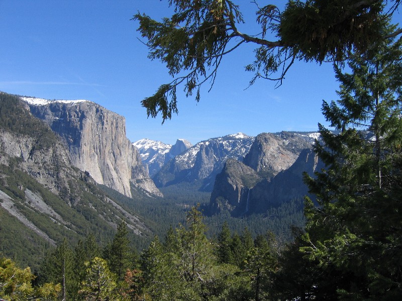
 I climb up a tree some 15 feet to snap a shot of the valley that barely
includes Bridalveil Falls.
I climb up a tree some 15 feet to snap a shot of the valley that barely
includes Bridalveil Falls.
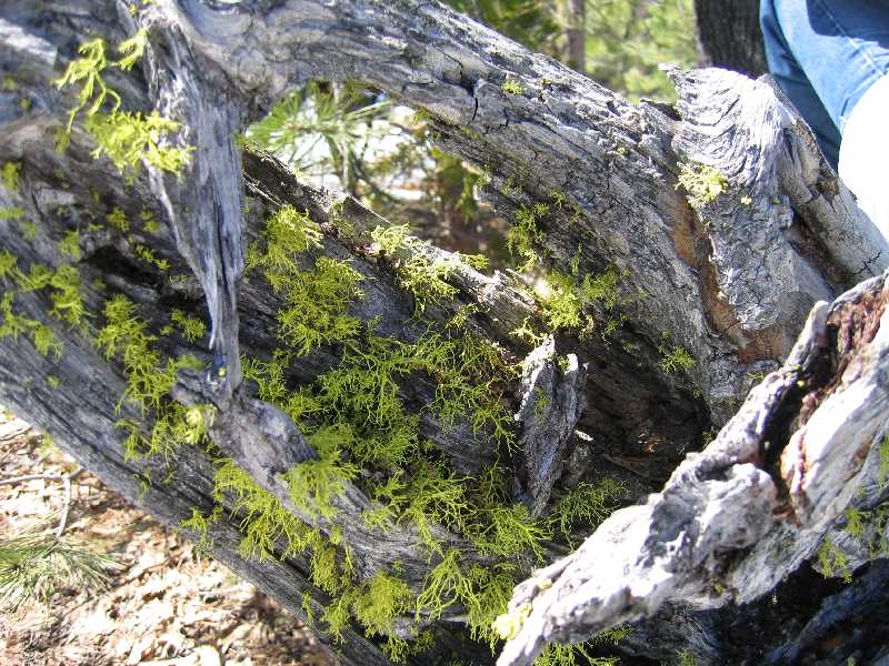 Then I tried another feature of the camera, macro. I should be able
to take a photo of an object that is only 5 inches away from the camera.
Here is a shot of some lichen.
Then I tried another feature of the camera, macro. I should be able
to take a photo of an object that is only 5 inches away from the camera.
Here is a shot of some lichen.
Just as we pack up and are ready to leave, a couple wanders over to us. I invite them to occupy our little spot that we pleasantly had all to ourselves. There were very few people on the trail on the way up, just one couple. On the way down we encounter the two hikers in addition to the couple at the top. It takes us only 20 minutes to walk/jog down to the car in our completely wet boots and socks. Our pants are wet up to our knees too. We change into dry clothes and look forward to getting home.